In this river segment, there are several diversion dams and power plants. During the times when water is diverted, these runs are unusable between the dam and the power plant return. In standard summer, fall and winter flows, there is not enough water to paddle these sections. Examples include the segment between the Fleish Diversion Dam and the Fleish Powerhouse return. This is also true for the sections downstream from the Verdi Diversion and Washoe-Highland Dams.
Always check the USGS website (Link below) for current flow information. Truckee's flow is highly regulated, with most river flow fully allocated through a system of water rights, set by the Truckee River Operating Agreement. Water levels on the Truckee River widely vary by season and the river is navigable depending on the flow rates and your experience level.
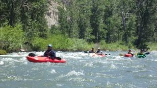
The best flows to enjoy this segment are over 700 cfs. Make sure to check water levels before your trip. View the daily streamflow conditions on the USGS Waterdata website, or use the links below for specific gauge sites along the river.
Farad Diversion Dam:
From Farad, paddlers can run at summer flows down to the Fleish Dam Portage Site, but it is a long walk up to the 80 Freeway to avoid the lower flows below the dam.
Fleish Diversion Dam:
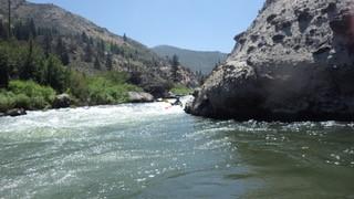
There are many Class 3-4 drops in the rapids below Fleish Dam. Some are marked on the map and named, others are just long, hard rapids with many rocks. During high flows, the walking bridge span over the river at the Fleish Dam is very close to rafters’ heads. This undercrossing has been called “Headhunter” by local paddlers, so be aware.
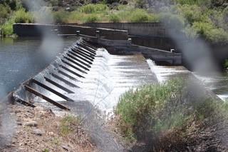
State Line/Steamboat Ditch Diversion:
Portage Right.
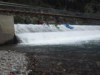
Verdi Diversion Dam:
This dam has a dangerous set of drops, so use caution when approaching. One must avoid running W/H on river left as it drops into boulders, so center or right (but not too close to the intake structure) are best. It often collects trees as a hazard but they can be seen from above usually. As there are private properties on the left, TMWA suggests portage on the right, but that is very arduous.
NOTE: Always use caution and portage as directed at all diversion dams: TMWA Dams are “Portage Left” and the State Line/Steamboat Ditch is “Portage Right.”
For an additional map of the Truckee River, see the TMWA website.
City of Reno events website: Things To Do | City of Reno
Visit the Reno-Sparks Convention & Visitors Authority website to get information on places to stay, eat and recreate.
See the TravelNevada website for articles and things to do in Verdi.
There are several agencies that manage the water in the Truckee River. The primary landowner for the river bed within Nevada is the Nevada Division of State Lands, but the water flow itself is managed by the Federal Water Master and Truckee Meadows Water Authority through the Truckee River Operating Agreement.
![]()
Download map files for your own use.
This segment begins at the I-80 bridge and offramp in Floriston. Parking is on the south side of the river, right off of the freeway. The take-out is in Crystal Peak Park, right before the 3rd Street bridge in Verdi. There are parking, picnic and bathroom facilities at the park.
In the Spring runoff months, water may be very fast and high. Paddlers should use caution and plan accordingly.
Bear activity is high in this area. Keep (people) (pets) (property) safe. Keep bears wild. For more information on the BearWise campaign, visit the Recreate Responsibly page, or click on this link to learn how to be BearWise in the outdoors.
Success! A new password has been emailed to you.